
Three fishing boats tied up for the night in a quiet Alaskan bay. The water around them stayed still. Then the mountain came down.
Lituya Bay, on the Gulf of Alaska, has long been used as an overnight anchorage by trolling boats working those waters in summer and early fall. That is how Don J. Miller of the U.S. Geological Survey described it in Professional Paper 354-C, the official account of what happened there on the evening of July 9, 1958.
The weather was clear, with high scattered clouds, and the head of the bay was visible from boat level. Around 8:00 p.m., Howard G. Ulrich and his 7-year-old son came in on the 40-foot troller Edrie and anchored in about 5 fathoms in a small cove on the south shore. About 9:00 p.m., Mr. and Mrs. William A. Swanson brought the Badger in, then anchored in about 4 fathoms in Anchorage Cove, on the north shore near the entrance, close to a third troller, the Sunmore. Miller wrote that all three boats were about 40 feet long, with two people aboard each.
A Crash Like an Explosion
A little after 10:15 p.m. local time, a magnitude 7.8 earthquake struck on the Fairweather fault. The U.S. Geological Survey still cites that shock as the trigger for the largest tsunami run-up ever recorded.
Ulrich was awakened by the violent rocking of the Edrie. He went on deck and watched the mountains at the head of the bay shake and shed rock. About two and a half minutes after he first felt the quake, he heard a deafening crash. In a written account later quoted by Miller, Ulrich said:
“The wave definitely started in Gilbert Inlet, just before the end of the quake. It was not a wave at first. It was like an explosion, or a glacier sluff. The wave came out of the lower part, and looked like the smallest part of the whole thing. The wave did not go up 1,800 feet, the water splashed there.”
Miller’s field work found that about 40 million cubic yards of rock had come down from a maximum altitude of about 3,000 feet on the steep northeast wall of Gilbert Inlet. The splash on the opposite wall reached 1,740 feet. A wave then ran the seven miles of the bay toward the mouth at a speed he put at probably between 97 and 130 miles an hour.
One Boat Rode It. One Went Over the Trees.
Ulrich could not get the Edrie’s anchor loose. He let out all the chain, about 40 fathoms, and started the engine. Midway down the bay, Miller reports, the wave looked to Ulrich like a straight wall of water possibly 100 feet high, shore to shore. As it came up on the Edrie, the front appeared very steep, and 50 to 75 feet high. No drop in the water around the boat warned him first. The anchor chain snapped as the boat rose. The Edrie was carried toward the south shore, maybe over it, then back toward the center of the bay in the backwash. Ulrich kept control after the wave passed. The boat took little damage.
The Badger was still at anchor when the wave lifted it and carried it across La Chaussee Spit, the low bar at the mouth of the bay. Miller, who interviewed William Swanson a week later, wrote that the boat rode stern first just below the crest, “like a surfboard.” Swanson looked down on the trees growing on the spit and believed he was about two boat lengths, more than 80 feet, above their tops. Outside the spit the wave broke, the Badger hit bottom and foundered, and the Swansons got off in a small skiff. Another fishing boat picked them up about two hours later.
The Sunmore had been anchored near the Badger at the start of the earthquake, Miller wrote, but was underway nearer the entrance when the wave arrived. It was swamped and went down with both people aboard. A later paper by Miller, excerpted by the Washington Department of Natural Resources, identifies them as Mr. and Mrs. Orville Wagner.
The Mark It Left
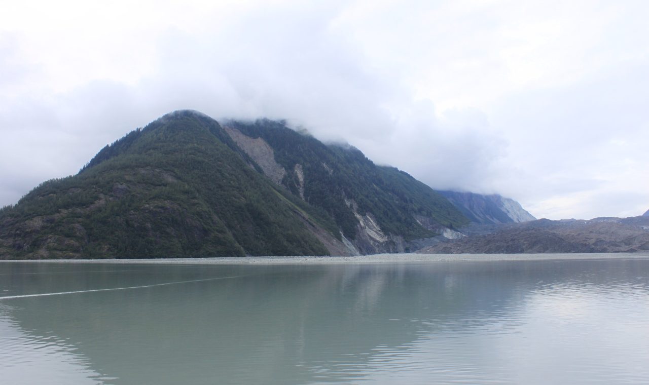
The wave destroyed the forest over about 4 square miles, Miller found, up to a maximum altitude of 1,720 feet, and as much as 3,600 feet inland from the high-tide line. Two of the three boats were sunk. Two people were killed. USGS still calls 1,720 feet the largest tsunami run-up ever recorded. That trimline is still easy to see. A 2010 photograph from the bay, looking toward Lituya Glacier, shows a sharp break between old forest and the younger growth on the slope that was stripped that night.
This was not the bay’s first giant wave. Miller dated earlier trimlines as well, including a wave on October 27, 1936, that reached 490 feet. In the official paper he did not treat 1958 as a freak that would never be repeated. “These waves are likely to occur again,” he wrote, “and should be taken into account in any future use of Lituya Bay.” Three trolling boats had done what fishermen had been doing there for years. They came in out of the Gulf to spend the night. The bay looked still. The danger was already loose on the mountain at the head of it, and it arrived as a wall.
Sources
- Don J. Miller, “Giant Waves in Lituya Bay, Alaska,” U.S. Geological Survey Professional Paper 354-C, 1960: https://pubs.usgs.gov/pp/0354c/report.pdf
- Don J. Miller, “The Alaska Earthquake of July 10, 1958: Giant wave in Lituya Bay,” Bulletin of the Seismological Society of America, v. 50, no. 2, excerpted in Washington DNR TsuInfo Alert: https://dnr.wa.gov/sites/default/files/2025-03/ger_tsuinfo_2008_v10_no3.pdf
- U.S. Geological Survey, “Earthquake Hazards in Southeastern Alaska”: https://www.usgs.gov/centers/pcmsc/science/earthquake-hazards-southeastern-alaska
Photo: The head of Lituya Bay in August 2010, with the 1958 trimline still visible as younger growth on the slope at left. Photo: Pohopetch, CC BY-SA 3.0, via Wikimedia Commons.